
Home and Wandering

In the fifteenth century, Europeans launched their caravels and galleons on what would become a merciless colonial crusade around the globe. They relied on a Chinese invention, the compass, which transformed the ocean from a terrifying void into a measurable grid. Learn about other key innovations that helped these smallpox-toting explorers navigate the seas, then discuss with your team: what would the world be like today if Europeans had simply stayed home?
A compass is a device that indicates direction. It is one of the most important instruments for navigation. Magnetic compasses are the best-known type of compass. While the design and construction of the magnetic compass have changed significantly over the centuries, the concept of how it works remains the same.
History of Compasses
The principle of magnetism has been observed by humans for thousands of years. Ancient Greeks observed the principle of magnetism, but they did not understand its relationship to the Earth or that a magnetized metal would point north. People in Ancient China also recognized magnetism. They learned that a magnetized bar of lodestone tied to a string would always point in the same direction. A unique aspect of these early compasses in China is that they were oriented to the south and were referred to as “south pointing spoons”. Many scholars believe that the Chinese were the first to use compasses for navigation.
Early compasses
Very early compasses were made of a magnetized needle attached to a piece of wood or cork that floated freely in a dish of water. As the needle settled, the marked end would point toward magnetic north. As engineers and scientists learned more about magnetism, the compass needle was mounted and placed in the middle of a card that showed the cardinal directions: north, south, east, and west. In time, 32 points of direction were added to the compass card.
Adjustments and Adaptations
By the 15th century, explorers realized that the “north” indicated by a compass needle was not the same as Earth’s true geographic north.This discrepancy between magnetic north and true north is called variation (by mariners or pilots) or magnetic declination (by land navigators), and it varies depending on location. In marine navigation, when ships evolved from being made of wood to being made of iron and steel, the magnetism of the ship affected compass readings. This difference is called deviation. Adjustments, such as placing soft iron balls (called Kelvin spheres) and bar magnets (called Flinders bars) near the compass, help increase the accuracy of the readings. In aircrafts deviation must also be taken into account.
Other Types of Compasses
The gyrocompass, invented in the early 20th century, uses a spinning gyroscope to follow Earth’s axis of rotation to point to true north. Since magnetic north is not measured, variation is not an issue. Once the gyroscope begins spinning, motion will not disturb it. This type of compass is often used on ships and aircraft.
A solar compass uses the sun as a navigational tool. It was used in the 19th and 20th centuries to survey land. Because a solar compass is not affected by iron metal deposits or location relative to the poles, a solar compass can be more accurate than a magnetic compass, particularly near the poles.
Another type of solar compass is an old-fashioned analog (not digital) watch. Using the watch’s hands and the position of the sun, it is possible to determine north or south. Simply hold the watch parallel to the ground (in your hand) and point the 12 o'clock mark in the direction of the sun.
Receivers from the global positioning system (GPS) have begun to take the place of compasses. A GPS receiver coordinates with satellites orbiting Earth and monitoring stations on Earth to pinpoint the receiver's location. Researchers have developed a so-called “SuperGPS” that is accurate within 10 centimeters (3.9 inches).
Ancient Polynesians have been using patterns in the sky to navigate the ocean for at least 2,000 years. A native Hawaiian historian, Charles Nainoa Thompson, developed a Hawaiian star compass in the mid-2000s to illustrate how Polynesians use the constellations for navigation.
Impact of the Compass
Compasses were essential for navigation during the Age of Exploration that began in the early 1400s. It contributed to trade, the circulation of knowledge, the spread of disease, colonization of new lands and enslavement
Additional Facts:
Many animals—such as certain types of ants, fish, and birds—use the sun as a compass to help them find direction. They use their internal biological clock to compensate for the sun shifting in the sky and maintain a straight course. Other animals—like pigeons—are able to navigate using the Earth’s own magnetic field. Their brains function like an internal magnetic compass to follow the Earth’s magnetic field.
If you were using a compass 800,000 years ago and facing north, the needle would point to the south magnetic pole. Since the magnetic north pole was discovered in the early 19th century, it has drifted northward by more than 966 kilometers (600 miles) and it continues to move about 40 miles per year.
Chinese also use compasses for spiritual orientation in an art/belief called fengshui, which harmonizes the energy of the environment.
The gyrocompass uses a spinning gyroscope to follow Earth’s axis of rotation to point to true north. This one was used by U.S. Navy Quartermaster Seaman Ricky C. Rodriguez aboard the dock landing ship USS Harpers Ferry at sea near Okinawa, Japan.

This model of a compass dates from the Han Dynasty, between the 2nd century B.C.E. to the 2nd century C.E. The spoon, magnetized with ore, served as this compass' needle.

Navigators like Christopher Columbus used the mariner's compass during the Age of Exploration in the 15th century, likely adapted from compasses developed by Chinese astrologers around 1050 AD.

These hunters from Little Diomede Island, Alaska, United States, use a compass to successfully navigate the Bering Strait.

This binnacle, from the royal yacht Victoria and Albert III, features so-called "Kelvin spheres" on either side. Kelvin spheres are iron balls that adjust the compass for variations in horizontal magnetic fields. Inside the binnacle (beneath the compass itself) are Flinder's bars, which adjust the compass for variations in vertical magnetic fields.

Robert Peary used this compass to reach the North Pole, allegedly the first person to do so. At the geographic North Pole, where Peary explored, compasses point south because the Magnetic North Pole is actually 800 kilometers (497 miles) away.


astrolabe
An astrolabe is an astronomical instrument dating to ancient times. It serves as a star chart and physical model of the visible half-dome of the sky. Its various functions also make it an elaborate inclinometer and an analog calculation device capable of working out several kinds of problems in astronomy. In its simplest form it is a metal disc with a pattern of wires, cutouts, and perforations that allows a user to calculate astronomical positions precisely. By rotating a movable metal disk (rete) with star pointers over a fixed plate engraved with coordinates, the user could model the sky’s motion. Aligning a star’s altitude with the date gave the time. The astrolabe, which is a precursor to the sextant, is effective for determining latitude on land or calm seas. Although it is less reliable on the heaving deck of a ship in rough seas, the mariner's astrolabe was developed to solve that problem.


sextant
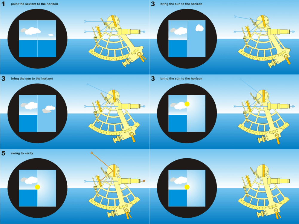
A sextant is a doubly reflecting navigation instrument that measures the angular distance between two visible objects. It is a precision optical instrument used to measure the angular distance between two visible objects, most commonly the altitude of the Sun or a star above the horizon. The estimation of this angle, the altitude, is known as sighting or shooting the object, or taking a sight. The angle, and the time when it was measured, can be used to calculate a position line on a nautical or aeronautical chart. It uses a mirror system to bring the horizon and the celestial body into alignment, allowing accurate readings even on a moving ship. The user looks through a telescope while moving an arm (index arm) along a graduated arc (60° = 1/6 of a circle, hence the name “sextant”). It was developed independently around 1730 by John Hadley (England) and Thomas Godfrey (America) and replaced the less accurate backstaff and Davis quadrant. Still carried on ships today as a backup to GPS, and essential for traditional celestial navigation training.
log tables and ephemerides
Log tables are printed reference books or charts listing logarithms (exponents to which a base, usually 10, must be raised to produce a given number). It was used with sextant readings: convert sight angles, compute time, solve spherical trigonometry for position (e.g., using the haversine formula) and was essential for reduction of celestial observations—turning raw sextant altitude into a line of position. Log tables were used in conjunction with ephemerides tables, which were tables giving the calculated positions of celestial bodies (Sun, Moon, planets, stars) at regular time intervals (e.g., every hour or day). It provides right ascension, declination, altitude, azimuth, and other coordinates. Navigators would compare sextant measurements against ephemeris data to find their position on Earth. Ephemerides are used in celestial navigation and astronomy. They are also used by astrologers, for example, GPS signals include ephemeris data used to calculate the position of satellites in orbit.


chip and log
The log and line (also called the chip log) is a mechanical speed-measuring device used to determine a vessel's speed in knots (nautical miles per hour). It is a simple but effective example of analog nautical technology. It needs three items: log, line and sandglass. A wooden quadrant (quarter-circle) weighted on the curved edge so it floats upright and resists being pulled through the water. A rope attached to the chip, marked with knots at specific intervals (every 47 feet 3 inches or 14.4 meters). A 28-second or 30-second timer.
A sailor drops the chip log over the stern. The chip's shape makes it "hold still" in the water while the ship sails away, paying out the line. Another sailor turns the sandglass. As the sand runs, the line is allowed to run freely. When the sand runs out (e.g., 28 seconds), the line is pinched. The number of knots that have passed over the stern in that time equals the ship's speed in nautical miles per hour (knots).
A nautical mile = 6,080 feet. Each knot on the line was spaced at roughly 47 feet 3 inches. Thus, the number of knots counted = speed in knots. In the 17th–18th centuries, the 28-second glass and 47-foot 3-inch spacing became widely accepted in the Royal Navy and other maritime powers.

.png)
chronometer
A marine chronometer is a precision timepiece that is carried on a ship and employed in the determination of the ship's position by celestial navigation. It is used to determine longitude by comparing Greenwich Mean Time (GMT) and the time at the current location found from observations of celestial bodies. When first developed in the 18th century, it was a major technical achievement, as accurate knowledge of the time over a long sea voyage was vital for effective navigation, lacking electronic or communications aids. The first true chronometer was the life work of one man, John Harrison, spanning 31 years of persistent experimentation and testing that revolutionized naval (and later aerial) navigation.

latitude and longitude
The invention of a geographic coordinate system is generally credited to Eratosthenes of Cyrene, who composed his now-lost Geography at the Library of Alexandria in the 3rd century BC. By the late Middle Ages, European navigators could determine latitude reliably and accurately whenever the sky was clear. In the Northern Hemisphere, Polaris's altitude above the horizon equals the observer's latitude. Using declination tables (ephemerides), the Sun's noon altitude gives latitude.This allowed them to sail east-west along a chosen latitude (running down a parallel).
Determining longitude was significantly harder because there is no natural reference like the equator or poles. Earth rotates 360° in 24 hours → 15° per hour → 1° of longitude = 4 minutes of time. To find longitude, you must know the time difference between your location and a reference meridian.

Longitude = (Local time−Reference time)×15°/hour
In 1714, the British Longitude Act offered £20,000 (millions in today's money) for a practical method to determine longitude at sea to within 0.5° (30 nautical miles). By the 1820s, chronometers became affordable and reliable. Captains carried three chronometers and averaged their readings.
We have Google Maps, or Baidu, but how do other animals know when they’ve arrived? From the monarch butterfly’s multigenerational migration to the globe-trotting of the humpback whale, animals follow astoundingly complex routes around the Earth. Learn more about their migration patterns and processes through the terms and examples below, then consider: are animals truly navigating, or just following their instincts? And is human activity making it harder for them to find their way?
monarch butterflies

Monarch butterflies undertake a multi-generational migration, with three to five generations spanning the annual cycle. While summer generations live only 2–6 weeks, the "super generation" (fourth or fifth) migrates up to 3,000 miles to Mexico, survives on stored fat for 6–8 months in diapause, and initiates the return trip. How does the "Super Generation" know where to go if it has never made the trip before?
The answer lies in their biology. They navigate using a sophisticated, time-compensated sun compass located in their brain. This internal system allows them to orient themselves based on the sun's position in the sky and adjust for the time of day, ensuring they maintain a consistent southward direction.
The full, multi-generational journey involves returning to the same location, but it is completed by the descendants of the original travelers.


Humpback whales are among the world's longest-migrating mammals, traveling over 5,000 to 13,000+ miles annually between cold polar feeding grounds and warm tropical breeding waters. Using unique tail patterns, researchers track these "globe-trotters," which show remarkable navigation to return to specific breeding areas.
humpback whales
They feed in cold, high-latitude waters in summer to build blubber, then migrate to tropical waters in winter for mating and calving. They can swim in nearly straight lines for over 2,000 km, showing remarkable navigational accuracy. A mother will bring her newborn calf on its first migration, teaching it the entire route before leaving it to fend for itself at about one year old.
The ocean is a dangerous place for a traveling whale, and their migration paths, known as "Blue Corridors," are filled with modern threats: ship strikes, entanglement with nets, underwater noises, and climate change. Collisions with vessels in busy shipping lanes (e.g., near the Panama Canal) are a major cause of death. Noise from ships and construction interferes with their communication and navigation, essentially "shouting" over their songs. Warming oceans are reducing sea ice and krill populations in Antarctica, threatening the whales' primary food source.

magnetoreception
Magnetoreception is the biological "sixth sense" that allows animals like humpback whales to detect and orient themselves using the Earth’s magnetic field. This ability acts as a global GPS, enabling whales to swim in remarkably straight lines across thousands of miles of open ocean where there are few visual landmarks.
This ability allows for three types of functions.
1) Directional finding: determine north-south orientation.
2) position fixing: infer latitude or position.
3) route learning: memorize and return to specific locations.
In birds, a protein called cryptochrome 4 (Cry4) is located in the retina of the eye. When hit by blue light, Cry4 triggers a quantum process called the radical pair mechanism. This creates entangled electrons that are extremely sensitive to the magnetic field's inclination (the angle relative to the Earth's surface). This sense is primarily processed in the right eye, sending directional data to the left hemisphere of the brain.
While the eye provides direction, another system tells the bird where it is on the globe by measuring magnetic intensity. Small clusters of magnetite (a magnetic mineral). Primarily found in the upper beak and connected to the brain via the trigeminal

nerve. New research also suggests the inner ear may play a role through electromagnetic induction.
This delicate system can be easily thrown off by human activity. Radio-frequency interference (from electronics or power grids) can disrupt the quantum reactions in the eye, effectively "blinding" a bird’s magnetic compass while leaving its other senses intact.
cryptochromes
Cryptochromes are a fascinating class of flavoproteins that act as nature's multi-tool for sensing light and magnetic fields. They are found in virtually all kingdoms of life, from bacteria to plants to animals, and they play a critical role in processes ranging from regulating our daily wake-sleep cycles to enabling migratory birds and monarch butterflies to navigate across continents.
Type I (Light-Sensitive): Found in insects and plants. These are true photoreceptors that are activated by light and are crucial for both circadian clock synchronization and, in some species, magnetoreception .
Type II (Light-Insensitive): Found in mammals, including humans. These no longer sense light directly. Instead, they function deep within the cell nucleus as core components of the circadian clock, independently of light to regulate gene expression .
Type IV (Bird-like): Found in birds and some other vertebrates. These are light-sensitive and are the primary candidates for the magnetic compass in migratory birds like the European robin
The link between a specific cryptochrome and magnetic behavior has been demonstrated directly in the monarch butterfly. In a 2021 study, researchers used gene-editing (CRISPR/Cas9) to knock out the butterfly's Type I cryptochrome (CRY1).


olfactory navigation
Olfactory navigation is the process by which animals use environmental odors to determine their position and guide movement toward a destination. While vision and sound travel in straight lines, scents are dispersed by wind and water in turbulent "plumes," requiring complex search strategies to follow them back to their source.
Animals employ different "taxis" (movement patterns) depending on their environment and sensory anatomy:
-
Anemotaxis (Wind-Guided): Many flying insects, such as moths, use a "cast-and-surge" strategy. Upon detecting a pheromone, they surge upwind; if they lose the scent, they "cast" side-to-side in a crosswind zigzag until they re-encounter the plume.
-
Klinotaxis (Comparison Sampling): Mammals like dogs or rats often turn their heads side-to-side, comparing the scent intensity of sequential sniffs to determine which direction is stronger.
-
Tropotaxis (Stereo Smelling): Animals with widely spaced sensors, such as hammerhead sharks or snakes with forked tongues, can compare scent concentrations between two points simultaneously to "smell in stereo".
For long-distance travelers like homing pigeons and migratory birds, scientists propose an "olfactory map".
-
Mosaic Model: Proposes that birds learn the distribution of odors around their home (e.g., forest scent to the north, sea salt to the south) within a ~100 km radius.
-
Gradient Theory: Suggests that birds can detect long-range atmospheric gradients, measuring how the concentration of certain molecules changes over hundreds of kilometers
Iconic examples in nature:
-
Salmon: These fish use the Earth's magnetic field for open-ocean travel but switch to olfactory imprinting once they reach freshwater. They "remember" the unique chemical signature of their birth stream to find it again years later.
-
Seabirds: Albatrosses and shearwaters have been shown to create "smell maps" of the open ocean, allowing them to navigate thousands of miles even when visual landmarks are absent.
-
Ants: Desert ants mark paths with pheromones to create a chemical "road map" for fellow colony members to follow to food sources.

echolocation
Echolocation, or biosonar, is a biological sensing technique where animals emit sound waves and interpret the returning echoes to navigate, identify objects, and hunt prey. By measuring the time delay between a call and its echo, animals can pinpoint a target's distance, while differences in intensity between ears reveal its direction. It can take place under water or in the air. Works in total darkness, murky water, and complex clutter where vision fails.
In air, such as with bats, sound travels at roughly 340 m/s. Bats produce high-frequency pulses (11–212 kHz) in their larynx and emit them through their mouth or nose. They receive echoes
through large, specialized ears. Under water, sound travels five times faster in water (approx. 1,500 m/s). Instead of a larynx, toothed whales use phonic lips in their nasal passages to create clicks. These are focused into a beam by a fatty forehead organ called the melon, and returning echoes are received through the lower jaw.
Human activities have profound and often detrimental effects on animals that rely on echolocation— primarily bats and toothed whales (dolphins, porpoises, sperm whales). Because echolocation depends on acoustic transparency, any human-generated noise or physical obstruction can degrade this sense, sometimes fatally.
Zugunruhe
Zugunruhe (pronounced zoog-oon-roo-ha) is a German term meaning "migratory restlessness". It describes the innate, anxious behavior migratory animals—primarily birds—exhibit when it is time to begin their seasonal journeys. Captive birds will hop, flutter their wings rapidly, and orient themselves toward their intended migration direction, even without a view of the outdoors. For species that migrate at night (like songbirds), Zugunruhe involves increased activity after dusk and a disruption of normal sleep patterns. This restlessness is often accompanied by an urge to overeat and rapidly build fat

reserves to fuel the upcoming flight. The phenomenon is driven by an internal "biological clock" and external environmental cues such as hormones and also length of daylight.
One Internet sensation chronicles the love story of Malena and Klepetan. He became a global sensation for flying over 8,000 miles from South Africa back to Croatia every year for 19 years to reunite with his injured mate, Malena.
Scientists quantitatively measure Zugunruhe using an Emlen funnel. A bird is placed at the base of a funnel-shaped cage with an ink pad at the bottom. As the restless bird tries to hop toward its migratory destination, its inked footprints on the sloping paper walls reveal both the intensity of the urge and the specific direction it intends to fly.
Thousands of white storks in regions like Spain and Portugal now choose not to migrate because landfills provide a reliable year-round food source. In these cases, the availability of food can suppress the traditional migratory urge.
Constant Frequency
Constant frequency (CF) is a specific type of echolocation signal that remains at a single, steady pitch for the entire duration of the call. Unlike Frequency Modulated (FM) calls, which "sweep" through a range of pitches, CF calls act as long, narrow-band tones that are uniquely suited for detecting movement and hunting in complex, "clutter-filled" environments like dense forests. This is in contrast to frequency modulated (FM) calls, which sweep downward in frequency.

For example, when a bat sends out a steady CF tone, it can detect the rapid flickering of an insect's wings. These "glints" appear as tiny fluctuations in the echo's frequency and amplitude, helping the bat distinguish a moving moth from a stationary leaf. When a CF bat emits its call toward a flying insect, the returning echo contains Doppler modulations caused by the moving wings of the insect. The bat hears the insect's "wing beat signature", a characteristic flutter that distinguishes what type of insect it is, such as moth, beetle, fly etc at 20–200 Hz (depending on species). This is called Doppler shift—the change in pitch caused by relative motion.

Frequency Modulation
Frequency modulation (FM) echolocation refers to the production of echolocation calls that sweep downward in frequency over a broad bandwidth during each call. This is the most common echolocation strategy among bats (the "FM bats") and is also used by some other animals like swiftlets and oilbirds. Unlike CF bats, which specialize in detecting motion, FM bats specialize in measuring distance with exquisite precision. Because the call contains many different frequencies, the animal can "clock" exactly when each specific frequency returns. This allows some bats to distinguish two objects separated by less than half a millimeter.
Sunlight polarization
Sunlight polarization provides animals with a "hidden" celestial compass. While direct sunlight is unpolarized, it becomes partially plane-polarized as it scatters off molecules in the Earth's atmosphere—a process called Rayleigh scattering. This creates a predictable pattern of electric field vectors (e-vectors) in the sky that animals can use for orientation, even when the sun itself is blocked by clouds.

The sky's polarization pattern is symmetrical around the solar meridian (an imaginary line passing through the sun and the zenith). Many species have specialized photoreceptors in a specific part of their eye called the Dorsal Rim Area (DRA) to detect these patterns.
Honeybees & Desert Ants: These are the "masters" of polarization. They use it as a primary compass for path integration, allowing them to find the shortest route home after a zig-zagging foraging trip.
Monarch Butterflies: Use polarized light to help calibrate their time-compensated sun compass during their multi-generational migrations.
Greater Mouse-Eared Bats: The only mammal confirmed to use this cue. They utilize the sky's polarization pattern at sunset to calibrate their internal magnetic compass.
Dung Beetles: Some species use the million-times-fainter polarized moonlight to maintain a straight course while rolling dung balls.
Small, lightweight polarization compasses are being developed for micro-drones that cannot carry heavy GPS or magnetic compasses, especially for indoor or GPS-denied environments.
Spatial Memory
Spatial memory is the cognitive ability of an animal to record, store, and recall information about its environment to navigate and locate essential resources. It allows animals to move beyond simple reflexes and create a "mental map" of their world. The ability to remember locations is rooted in specialized neurons, primarily located in the hippocampal formation
Place cells are neurons in the hippocampus that fire only when an animal is in a specific location, creating a mosaic of "place fields" that represent the environment. Found in the entorhinal cortex, these grid cells fire in a hexagonal grid pattern across the environment, providing a coordinate system for tracking distance and direction. Head directional cells act like an internal compass, firing based on which way the animal's head is pointing, regardless of its location.
Different ecological pressures have led some species to develop "supersized" spatial memories. Animals like Clark’s Nutcrackers and Squirrels can hide thousands of food items across a wide territory and recover them months later. Research shows that these species often have a larger hippocampus relative to their brain size than non-hoarding relatives. Recent movement models suggest wolverines use spatial memory to plan energetically efficient "least-cost" routes through rugged, unseen mountain terrain, often targeting destinations up to 10 km away.
.jpg)
.jpg)


Some birds start their education for migration while still babies in their nests. How? They watch the stars. In 1967, ornithologist Stephen Emlen published his study of how Indigo Buntings learn to navigate. He raised baby Indigo Buntings in a planetarium. Instead of circling the Pole Star, Emlen's artificial night sky rotated about Betelgeuse, a star in Orion. That made the stars move slowest and arc most tightly around Betegeuse.
Details of his experiment include placing buntings in funnel-shaped cages with ink pads at the bottom. As the birds exhibited Zugunruhe (migratory restlessness), their inked footprints on the funnel walls
showed which direction they were trying to fly. By testing them in a planetarium, Emlen found that when he rotated the artificial star field, the birds changed their orientation to match the new "North". They specifically look for the point in the sky that rotates the least. By identifying Polaris and surrounding constellations like Ursa Major and Cassiopeia, they establish a reliable reference for North. They possess a biological clock that allows them to adjust their angle of orientation as the stars move across the sky throughout the night.

The landmark study, "Insect orientation to polarized moonlight," published in Nature in 2003, was the first to show that an animal uses the polarization pattern of moonlight for orientation. The discovery that dung beetles use starlight "was an accident more than anything," explains study author Eric Warrant, professor of zoology at the Lund University in Sweden. His research group was studying how the beetles used the polarized light patterns of the moon to stay on their paths, when one moonless night they made a surprising observation—the beetles maintained straight trajectories. "Even without the moon—just with the stars—they were still able to navigate," Warrant says. "We were just flabbergasted."
The researchers concluded that in the wild, the beetles weren't using individual stars, but the bright stripe of starlight from the Milky Way as a sort of compass. The Milky Way is much easier to see in the Southern Hemisphere (South Africa) where the researchers did their experiments, Warrant says. "It's probably much more visible for an insect eye—especially a sensitive insect eye like these beetles have."
Dung beetles "see about 1000 times better than honey bees, which have the best daytime vision," explains James Gould, an evolutionary biologist and an expert in insect communication and navigation from Princeton University. To a dung beetle, the Milky Way probably looks like a dim band of variable brightness stretching across the night sky. "All they have to do is to maintain a heading relative to that landmark and they'll be OK," he says.


New research suggests that honeybees memorize linear landmarks like canals and streams to find their way home. As expert travelers, honeybees are known to use the sun, their sense of smell, and changes in polarized light in the sky to navigate as they fly. They even use the tiny hairs on their bodies to sense a flowers’ electric field. This new study takes a deeper look at the role that memory of specific visual cues plays in their navigation.
“Here we show that honeybees use a ‘navigation memory’, a kind of mental map of the area that they know, to guide their search flights when they look for their hive starting in a new, unexplored area,” Randolf Menzel, a neurobiologist from Free University of Berlin in Germany and study co-author, said in a statement. “Linear landscape elements, such as water channels, roads, and field edges, appear to be important components of this navigation memory.”
Menzel and his team caught 50 experienced forager honeybees in 2010 and 2011. In unfamiliar territory, these bees fly in exploratory loops in different directions and distances that are centered from where they were released. The most notable linear landmarks were
two parallel irrigation channels that ran northeast and southwest. The test area didn’t include any other landmarks that honeybees are known to use to navigate, such as structured horizons, or vertical elements that stand out like trees or plants. Next, the team glued a tiny transponder on the bees’ backs and released them in a test area that was too far away from their home hives for them to already be familiar with. They then used a radar that could detect the transponders at a distance of up to 2,952 feet in the test area. According to the study, the results suggest that the bees can retain a navigational memory of their home territory based on landmarks and then try to generalize what they saw in the test area to find their way home.

Homing pigeons are famous for being able to navigate extremely long distances. Their “homing” is so reliable that they were used in World War I and World War II to deliver messages over enemy lines.
Researchers have discovered a small spot on the beak of pigeons and some other birds that contains magnetite. Magnetite is a magnetized rock, which may act as a tiny GPS unit for the homing pigeon by giving it information about its position relative to Earth’s poles. Researchers have also found some specialized cells in birds’ eyes that may help them see magnetic fields.
Pigeons use a "multivariable" navigation system that acts like a built-in GPS:
1) magnetoreceptors: They can detect Earth's magnetic fields to stay on course, possibly through iron-rich cells in their inner ears or light-sensitive proteins in their eyes.
2) Infrasound: They can hear ultra-low-frequency sound waves (as low as 0.1 Hz) from the Earth’s crust or distant oceans, using them as acoustic "guideposts".
3) Visual Mapping: In familiar areas, they literally follow the "human" way home—following highways, railways, and making 90-degree turns at specific landmarks.

The findings, reported in the April 29, 2004, issue of Nature, may enhance conservation efforts to protect endangered turtle species and suggest new methods of human navigation, according to the researchers. The study was led by University of North Carolina marine biologists Kenneth and
Catherine Lohmann along the Atlantic coast of Florida and was supported by a $413,000 grant from the National Science Foundation. According to Michael Greenfield, a director with NSF's Animal Behavior Program, "Older turtles would need a more accurate map, as they must do more than simply orient seaward and enter a current. They have to find a specific beach on which to land, mate, and -- for females -- lay eggs. This all demands considerable accuracy in orientation."
When the turtles were exposed to a magnetic field characteristic of a coastal area about 209 miles north of their homes, they invariably swam southward. In contrast, turtles exposed to a field that exists an equivalent distance to the south responded by swimming northward. The findings showed that turtles can distinguish between the magnetic fields that characterize different geographic locations. Moreover, turtles responded to the magnetic fields by orienting themselves in a direction that would have led them towards the capture site had they been where each magnetic field naturally occurs.
Cataglyphis fortis (Tunisia), C. velox (southern Spain), and the Melophorus bagoti (central Australia) have mastered the art of precise path integration. These remarkable ants can venture out to forage for food hundreds of meters away from their nest. Equipped with a natural step counting mechanism and a time compensated celestial compass, they navigate using the sun’s position and the UV polarization patterns in the sky. It’s impressive, considering they operate with brains that consist of just 500,000 neurons, in stark contrast to the 85 billion neurons found in humans. Their nests are simply small holes dug into the ground. While seeking dead insects during the sweltering heat of midday – which helps them avoid both

predators and competition – soil temperatures can soar to a scorching 70°C (158°F). Cataglyphis ants rely on two primary navigation methods: path integration, which allows them to navigate without landmarks, and view-based landmark guidance, enabling them to memorize, recall, and follow various routes through their complex environments.
Given the availability of a rich array of cues, from idiothetic (self-motion) information to input from sky compasses and visual information through to olfactory and other cues (e.g. gustatory (taste), magnetic, anemotactic (wind) or thermal) it is no surprise to see multimodality in most aspects of navigation. We show that despite their impressive homing accuracy, ants returning from long foraging journeys face a mortality rate of up to 20%.
“We know where we are,” sang Moana’s ancestors—and they knew it without maps, compasses, or access to Starlink. Instead, Polynesians drew on a complex system of non-instrument navigation, including the star compass, ocean swells, and animal sightings. In the Arctic, the Inuit use the night sky and other markers to find their way—even in a landscape almost uniformly white with ice and snow. With your team, explore traditional navigation methods (including some that may be legendary) and consider: how does the journey change if the map is not on our screen but in our mind? Would the world be better off if more people knew how to navigate it without their phones?
"We Know The Way" is a central anthem from Disney's Moana (2016), written and performed by Lin-Manuel Miranda and Opetaia Foa'i. It serves as a tribute to the ancestral heritage of Polynesian wayfinding and the "Long Pause"—a historical period where Pacific voyaging mysteriously stopped for nearly 1,000 years.
Moana discovers the hidden cave of ships and realizes her people were once wayfinders who stopped voyaging for 1,000 years. As she sees visions of her ancestors sailing across the ocean, the song swells—showing her accepting her calling.
The lead voice singing the ancestral chants is Opetaia Foa'i himself (the founder of Te Vaka). Lin-Manuel Miranda intentionally gave him that role to keep the Polynesian sound authentic.


"At night we name every star, we know where we are": Wayfinders used "star compasses," memorizing the rising and setting points of stars to determine direction. "We read the wind and the sky": Navigators interpreted natural signs like cloud formations, wind direction, and the flight patterns of birds to detect nearby land. "We keep our island in our mind": A literal wayfinding concept where the navigator holds a constant mental image of their home island to calculate their relative position on the open ocean. The Hand Method: While not explicitly in the lyrics, the scene features Moana using her hand as an angular ruler to measure star altitude, which helps determine latitude.
A revival of the art and science of wayfinding is underway among the Pacific islands, led by Nainoa Thompson, the first modern-day Polynesian to learn and use wayfinding for long-distance, open-ocean voyaging. Nainoa studied wayfinding under Mau Piailug, a master navigator from the island of Satawal in Micronesia.

He also studied the movement and positioning of celestial bodies with Will Kyselka at the Bishop Museum planetarium in Honolulu, and oceanography and meteorology at the University of Hawai‘i. Mau navigated the first voyage of the Hōkūle‘a to Tahiti in 1976; Thompson served as wayfinder on voyages of Hōkūle‘a in 1980 and 1985–87. In 1992, he began training new navigators from Hawai‘i and other Pacific islands to perpetuate the tradition.
The foundational framework behind the master art of wayfinding, used by our crewmembers and navigators, is the Hawaiian star compass developed by master navigator Nainoa Thompson. The star compass is a mental construct and not physical like a western compass. The visual horizon is divided into 32 houses, a house being a bearing on the horizon where a celestial body resides. Each of the 32 houses is separated by 11.25˚ of arc for a complete circle of 360˚.


During William Edward Parry’s 1821-23 push for the Northwest Passage, Lieutenant William H. Hooper queried Toolemak, an Iglulingmiut shaman, about conditions along their prospective route. After some chanting, Toolemak called upon his spirit helper or tuurngaq, who told the assembled that pack ice would force the explorers’ ships to turn around and sail back to kabloona-noona, “White Man’s Land.” As predicted, jams in Fury and Hecla Strait south of Baffin Island thwarted the expedition, which promptly left Canada’s Arctic.
But with Arctic societies in transition, with language loss, handheld GPS gadgets, and with long-distance travel overland and by sea greatly diminished, this knowledge is fading. Artificial features such as radar towers and radio masts are replacing drift patterns and stars as beacons for young Inuit hunters.
The kit of wayfinding aids was passed on orally from one generation to the next, by listening to and observing expert elders as much as by trial and error. It required deciphering currents and triangulating constellations, interpreting atmospheric phenomena, migrations of birds, whales, and caribous, and registering the shapes, angles, and bedding of “land waves”—snowdrifts.
Their accuracy and deep knowledge of the terrain was impressive and came with experience. Some Inuit depicted familiar settings, their bays, lakes, lagoons, and hills in a detailed scrimshaw denoting their travels and toils. Exaggeration in size could signify vital shelter or good hunting sites. Lesser known coasts or mountains on the periphery appeared vague, diminished in detail and size compared to their home ground. Women intimately knew areas near camps, the orbits for snaring hares, picking berries, digging up roots. Men focused on distant trading locations, on portages, passes, furbearers’ whereabouts, and on braided grooves caribou herds scored into vast tundra.


The rare Inuit driftwood maps of Greenland’s Ammassalik Archipelago could be fingered under a parka or inside a kayaker’s hatch, in rain, fog, or polar night. Washed overboard, these charts would float. Their carved nobs and notches—capes, islands, and inlets of that sea-riven stretch—embody a passable fringe close to shore.
For nomadic cultures settling extreme, marginal environments, traveling light was a requirement for survival; “tools” were best carried inside one’s head, fashioned from local materials as needed and readily discarded.
In some contemporary Inuit communities, orienteering know-how has endured the arrival of snowmobiles and TVs although climate change makes much sea ice lore
obsolete. A researcher from Ontario’s Carleton University accompanied a hunter who retrieved seven fox traps his uncle had set across 20 square kilometers of seemingly flat, monotonous tundra 25 years ago. The traps lay buried under snow. The hunter collected them all in roughly two hours.
Linguists say that about one-third of the world’s languages label the space surrounding a person’s body not with the terms of “left” and “right” but with cardinal directions. Speakers of such languages are said to be more skilled at keeping track of their relative position even in unfamiliar places.
A Viking legend tells of a glowing "sunstone" that, when held up to the sky, revealed the position of the sun even on a cloudy day. It sounds like magic, but scientists measuring the properties of light in the sky say that polarizing crystals--which function in the same way as the mythical sunstone--could have helped ancient sailors to cross the northern Atlantic. A review of their evidence was published January 31 in Philosophical Transactions of the Royal Society B.
The Vikings, seafarers from Scandinavia who traveled widely and settled in swathes of Northern Europe, the British Isles and the northern Atlantic from around 750 to 1050 AD, were skilled navigators, able to cross thousands of kilometers of open sea between Norway, Iceland and Greenland. Perpetual daylight during the summer sailing season in the far north would have prevented them from using the stars as a guide to their positions, and the magnetic compass had yet to be introduced in Europe--in any case, it would have been of limited use so close to the North Pole.
Viking legends, including an Icelandic saga centering on the hero Sigurd, hint that these sailors had another navigational aid at their disposal: a sólarsteinn, or sunstone.The saga describes how, during cloudy, snowy weather, King Olaf consulted Sigurd on the location of the sun. To check Sigurd's answer, Olaf "grabbed a sunstone, looked at the sky and saw from where the light came, from which he guessed the position of the invisible sun." In 1967, Thorkild Ramskou, a Danish archaeologist, suggested that this stone could have been a polarizing crystal such as Icelandic spar, a transparent form of calcite, which is common in Scandinavia. Light consists of electromagnetic waves that oscillate perpendicular to the direction of the light's travel. When the oscillations all point in the same direction, the light is polarized. A polarizing crystal such as calcite allows only light polarized in certain directions to pass through it, and can appear bright or dark depending on how it is oriented with respect to the light.
However, in one study, the researchers took photographs of partly cloudy or twilight skies in northern Finland through a 180-degree fisheye lens, and asked test subjects to estimate the position of the sun. Errors of up to 99 degrees led the researchers to conclude that the Vikings could not have relied on naked-eye guesses of the sun's position. The polarization was not as strong, but Åkesson believes that it could still have provided Viking navigators with useful information.
In some video games, such as Zelda and Yakuza, the unexplored regions of the map are cloudy until you visit them. The real world used to be more like that: Columbus sailed into the unknown (and never reached his intended “there”) and you couldn’t know what was around the riverbend until you went around the riverbend. Some mapping apps now offer the chance to recreate that experience by masking regions of the map until you set foot in them. Check out one example, Fog of World, which promises us the chance to “experience a richer life”, then discuss with your team: can limiting easy access to knowledge really enrich our experience of the world? If so, what else should we keep “foggy”?
With Fog of World, you relive those destinations and the path that lead you there. Map it; draw each stride out for you to see. Look at the work of art you’ve created - just by traveling. By knowing you cannot be contained. Apps like Fog of World tap into a concept called lifelogging—turning the invisible data of your life into a tangible "work of art." While animals use navigation for survival, humans use these features to satisfy a deep-seated need for narrative and achievement. Like a map version of a bullet journal.
By covering the world in a "fog" that only your GPS can clear, these apps turn the real world into a massive video game. This

triggers dopamine rewards for taking the "long way home" or exploring a side street you’d normally ignore. It transforms a routine commute into a quest for "map completion." Just as birds have a mental "spatial map," these apps provide a digital horizonal. Seeing a thick web of lines over your hometown versus a single thin line through a foreign country visually represents your "territory" and your growth. It proves, as your quote says, that you "cannot be contained."
In the 2004 film The Terminal, a traveler lands at an American airport only to discover that his country’s government has collapsed. With his passport no longer valid, he can’t enter the United States, but he also can’t go home again—so he ends up living at the airport indefinitely. Watch highlights from the film with your team, then consider the real case of Mehran Karimi Nasser that inspired it. Why do you think Steven Spielberg made the changes to the story that he did? And what should governments do in situations like these? You may also want to look into some more recent examples of people stuck in airports, including that of Edward Snowden.
Viktor Navorski (Tom Hanks), a traveler from the fictional country of Krakozhia, arrives at New York's JFK airport only to discover that, during his flight, a coup d'état has occurred back home. His passport is now invalid because the U.S. does not recognize Krakozhia's new government. Viktor is trapped. He cannot enter the United States (no valid papers) and cannot be deported (no recognized country to return to). The airport's strict security chief, Frank Dixon (Stanley Tucci), sees Viktor as a bureaucratic headache and tries to force him to leave the terminal on his own by making his life miserable.
Viktor refuses to break the rules. Instead, he settles into the terminal's international lounge, turning it into a home. He learns English, befriends the airport staff (including a catering worker played by Diego Luna and a janitor played by Kumar Pallana), finds work as a construction laborer inside the airport, and even helps a desperate fellow traveler. While the movie is a comedy-drama about a man stuck in limbo, the deeper story is about patience, integrity, and the meaning of home. Viktor isn't just waiting for his country to stabilize—he's fulfilling a secret promise made to his dying father. The classic scene about "His goat!" is very touching.

The Terminal Was Inspired By The Story Of Mehran Karimi Nasseri a man from Iran. The Iranian refugee resided at the departure lounge of Terminal 1 of Paris's Charles de Gaulle Airport for a shocking span of 18 years. Due to his unconventional housing situation, Nasseri became something of a celebrity, and his 2004 autobiography, The Terminal Man (co-written by British writer Andrew Donkin).
Nasseri was born in Iran but moved to the United Kingdom when he was 28. The British sojourn was in 1973 when Nasseri was pursuing a three-year course in Yugoslav studies at the University of Bradford. With the protests against the Shah of Iran becoming more widespread in the 1970s, Nasseri added that he was expelled from his home country in 1977 for getting involved in such anti-state activity.
When he arrived at CDG in 1988 without a passport (he said his briefcase was stolen in Paris), Belgian officials agreed to grant him refugee status, but the paperwork never arrived. French authorities could not deport him anywhere, and he refused to leave without the papers. He lived on a red plastic bench, slept, ate, wrote his diary, read magazines, and accepted food/clean clothes from airport staff and travelers who grew fond of him. He became a local celebrity. In 2006, he was hospitalized for illness and later moved to a Paris shelter. He returned to the airport to live again in 2022 and died of a heart attack in the terminal that same year.


In January 2021, local authorities arrested a 36-year-old man named Aditya Singh after he had spent three months living at Chicago's O'Hare International Airport. Since October, he had been staying in the secure side of the airport, relying on the kindness of strangers to buy him food, sleeping in the terminals and using the many bathroom facilities. It wasn't until an airport employee asked to see his ID that the jig was up. As airports take the form of mini cities with endless strangers transiting, it becomes a great place to blend in and for some, take refuge and live. Many of these cases have to do with seeking political asylum as a refugee.
Other long-term airport residents include Edward Snowden, the NSA leaker, who spent more than a month in a Russian airport in 2013 before receiving asylum. And then there is the saga of Sanjay Shah. Shah had travelled to England in May 2004 on a British overseas citizen passport. Immigration officials, however, refused him entry when it was clear he intended to immigrate to England, not merely stay there the few months his type of passport allowed. Sent back to Kenya, Shah feared leaving the airport, as he had already surrendered his Kenyan citizenship. He was finally able to leave after an airport residency of just over a year when British officials granted him full citizenship.
Covid-19 also complicated travel in regards to shutdowns and visas, with a few long-term involuntary airport residents. For example, an Estonian named Roman Trofimov arrived at Manila International Airport on a flight from Bangkok on March 20, 2020. By the time of his arrival, Philippine authorities had ceased issuing entry visas to limit the spread of COVID-19. Trofimov spent over 100 days in the Manila airport until personnel at the Estonian embassy were finally able to get him a seat on a repatriation flight.
Major airports in both the United States and Europe have long functioned – though largely informally – as homeless shelters. In 1986, for example, the Chicago Tribune wrote about Fred Dilsner, a 44-year-old former accountant who had been living at O'Hare in Chicago for a year. The article indicated that homeless individuals had first started showing up at the airport in 1984, following the completion of the Chicago Transit Authority train link, which provided easy and cheap access. The newspaper reported that 30 to 50 people were living at the airport, but that officials expected the number could climb to 200 as the winter weather set in.

Edward Snowden was a US defense contractor whofled the United States to avoid prosecution after leaking classified information about government surveillance programs. He has consistently stated that his actions were motivated by a desire to expose what he saw as unconstitutional mass surveillance, but he did not believe he would receive a fair trial if he remained in the U.S. to face the consequences. He pointed to the case of Chelsea Manning (formerly known as Bradley Manning), a U.S. Army private who was sentenced to 35 years in prison for leaking documents to WikiLeaks.
On August 2013, after nearly six weeks in hiding at Moscow's Sheremetyevo airport, Edward Snowden walked calmly out of the transit area, ducked into a car and was driven away
unnoticed. It was an anti-climactic end to one chapter of a saga watched by the world in which the American, wanted in Washington for leaking details of secret U.S. surveillance programs, stayed out of sight for almost 40 days and nights.
In June 2013, Snowden flew from Hong Kong to Moscow's Sheremetyevo International Airport, intending to transit to a country for asylum . However, the U.S. had revoked his passport, leaving him unable to board any onward flight . He was effectively trapped in the airport's international transit zone—a legal no-man's land where he had not formally entered Russian territory but could not leave.
The U.S. government filed espionage charges against Snowden and demanded his extradition, urging Russia to expel him. President Vladimir Putin confirmed Snowden was in the transit area but stated Russia would not extradite him, as there was no extradition treaty and Snowden had committed no crime on Russian soil. Putin publicly expressed a desire for Snowden to choose a final destination and leave quickly. The stalemate ended after 39 days. On August 1, 2013, Russian authorities granted Snowden temporary asylum for one year, which allowed him to finally leave the airport and enter Russia. He has been in Russia ever since.
Immigrants by land and sea can also face obstacles to entry when they reach their destinations. Consider the case of the St. Louis, a ship carrying Jewish refugees from Nazi Germany in 1939. The passengers were denied entry in the United States, Canada, and Cuba, and many ultimately died in Nazi concentration camps. More recently, the United States has stopped allowing people to ask for asylum at its southern border; European countries are also increasingly reluctant to accept refugees. Explore the reasons behind these anti-immigrant policies; do some make more sense than others? Then, discuss with your team: how open should countries be to those arriving at their borders in dire need? Should there be limits on the number admitted, and, if so, how should those limits be calculated?
The St. Louis is undoubtedly a stain in US history and reflected one of the cruelest moments in the 20th century. The plight of German-Jewish refugees, persecuted at home and unwanted abroad, is illustrated by the voyage of the SS "St. Louis." On May 13, 1939, the SS "St. Louis," a German ocean liner, left Germany with almost a thousand Jewish refugees on board. The refugees' destination was Cuba, but before their arrival the Cuban government revoked their permission to land. The "St. Louis" was forced to return to Europe in June 1939. However, Great Britain, France, Belgium, and the Netherlands agreed to accept the stranded refugees. After German forces occupied western Europe in 1940, many "St. Louis" passengers and other Jewish refugees who had entered those countries were caught up in the Final Solution, the Nazi plan to murder the Jews of Europe.

In November 1938, Kristallnacht, a state organized pogrom known as the “night of broken glass," left Jewish businesses, homes and places of worship in shambles. For many Jews, Kristallnacht was a clear signal to leave. At the time, German Jews were being pushed by the Nazis to emigrate, and the danger faced by Jews elsewhere in Europe led some to find ways to leave the continent for good. The Jewish people aboard the St. Louis had made the difficult decision to start new lives thousands of miles away. The ship's destination was Cuba, where most passengers planned to live while awaiting entry into the United States.
As the M.S. St. Louis cruised off the coast of Miami in June 1939, its passengers could see the lights of the city glimmering. But the United States hadn’t been on the ship’s original itinerary, and its passengers didn’t have permission to disembark in Florida. As the more than 900 Jewish passengers looked longingly at the twinkling lights, they hoped against hope that they could land. Those hopes would soon be dashed by immigration authorities, sending the ship back to Europe. And then, nearly a third of the passengers on the St. Louis were murdered.
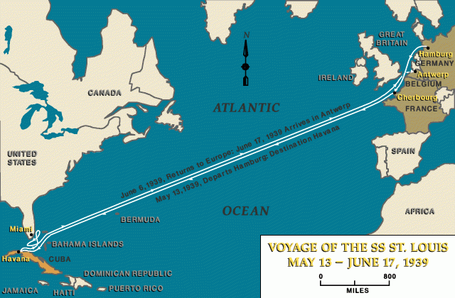
The passengers waited aboard for an entire week. As time passed, they became increasingly desperate. One passenger, Max Loewe, slashed his wrists, jumped overboard and was sedated by authorities before being admitted to a Havana hospital. Passengers formed a committee and begged Cuban President Federico Laredo Bru, and then U.S. President Franklin D. Roosevelt, for sanctuary. When it became clear that Cuba was indifferent, if not hostile, to the refugees, the ship sailed toward the United States. They didn’t find sanctuary there, either. An attempt to land in Miami was rejected by immigration authorities, and a desperate cable to Roosevelt by some passengers was ignored. Though a U.S. diplomat had tried to negotiate with Cuba to admit the refugees, the U.S. itself was unwilling to open its doors. The passengers would have to abide by an existing quota system that allowed only about 27,000 people from Germany and Austria into the United States. The world’s refusal of the St. Louis’ desperate refugees was a death sentence for 254 refugees—approximately half of the number who had returned to the European continent in 1939.
The forces of anti-immigration politics are upending liberal governments all over Europe — with voters in 21 of 28 EU countries citing immigration as the top issue facing the continent, according to a recent Eurobarometer survey. The big picture: That's a disconnect with the reality — migrant arrivals in those countries have dropped significantly. But the political turmoil is spreading, to the point where there's even a far right, anti-immigrant party on the rise in Sweden, one of the world’s most progressive countries.

That's a sign that the immigration backlash is putting pressure on governments around the world, not just in the United States. More than 1 million migrants entered Europe during the 2015 migrant crisis, deepening the anti-immigrant sentiment that has fueled a resurgence of the far-right, and sweeping parties with hardline immigration platforms into power.
In Hungary, Prime Minister Viktor Orban's Fidesz party — which decries multiculturalism and has jailed human rights lawyers who assist asylum-seekers — won a landslide election in April. In Italy, the anti-establishment 5 Star Movement and far-right League joined forces in June to form a populist coalition government. One of their first moves in office was to prevent a ship carrying 629 migrants from docking on Italy's shores. Leaders have also ridden immigration rhetoric to electoral success in Austria, the Czech Republic and Slovenia. But it is in countries like Germany, France and the U.K. where pressure on center-right and center-left governments to adopt anti-immigrant measures is playing the biggest role in tilting Europe's political scales.
Consider the following poems that speak to the immigrant experience. Are they expressing something universal, or are they too constrained by the specific experience of migrating to the United States? In what ways do they relate to the idea of thresholds and liminal spaces?
Emma Lazarus | “The New Colossus” (1883)

Born into a wealthy, educated Jewish family in New York City. She was part of the city's literary elite and corresponded with thinkers like Ralph Waldo Emerson. The pogroms (violent anti-Jewish riots) in Russia in the early 1880s transformed her. She became deeply involved in Jewish refugee aid, teaching English to immigrants and advocating for their cause. The poem was written as part of a fundraising campaign for the pedestal of the Statue of Liberty. The statue itself was a gift from France, but America had to pay for the base. Lazarus was asked to contribute a poem to an art auction to raise money. Lazarus redefines "colossus." The "Old Colossus" was the ancient Colossus of Rhodes—a towering bronze statue of the Greek sun god Helios, built to celebrate military power and conquest. It stood as a symbol of strength over others. During WWII, it was used to welcome refugees. Today, it is the most quoted description of what the Statue of Liberty means.
Adrienne Rich | “Prospective Immigrants Please Note” (1963)
Rich was born in Baltimore to a Jewish father and Protestant mother. She graduated from Radcliffe College and won the Yale Younger Poets Prize in 1951 for her first collection A Change of World. Being half-Jewish in a family that downplayed that heritage gave Rich a personal connection to questions of belonging, exile, and the immigrant's complex relationship with America. First published in Rich's 1963 collection Snapshots of a Daughter-in-Law, this poem marks her transition toward a more direct, politically engaged voice.
The poem's central image is a door—but it is not the welcoming, torch-lit "golden door" of Emma Lazarus. Rich's door is stripped of all illusion. It offers no welcome, no promise, and no guarantee . It is, quite simply, a door. The decision to pass through it—to immigrate—is left entirely to the individual. The final line of each stanza reveals the poem's core truth: neither path is safe. Neither guarantees happiness. And the door itself makes no promises.


Marilyn Chin | “We Are Americans Now, We Live in the Tundra” (1987)
Marilyn Chin was born in Hong Kong and raised in Portland, Oregon. The narrator is in San Francisco but her heart is in China. China is imagined not as a powerful nation but as "a giant begonia"—beautiful, fragrant, but "bitten / By verdigris and insects." The flower is decaying, suggesting that the China she remembers is itself fragile, perhaps lost to time. The poem shows a blended culture of a Chinese American immigrant, such as a Chinese girl singing the blues, which is a classic American style of music.
Ling Ling and Xing Xing were real pandas gifted by China to the United States as diplomatic gestures. Their refusal (or inability) to mate becomes an allegory for the immigrant's struggle to reproduce—not just biologically, but culturally. "We are not impotent, we are important" is a defensive assertion of worth that rings hollow. Their situation is not their fault; they "blame the environment, [blame] the zoo"—just as the immigrant blames the new country for her failures to thrive.
The speaker explicitly rejects the plants of her heritage (bamboo, coconut palms) and chooses the staples of North American agriculture. But there is a strange, almost grotesque image at the end: "old swine / To milk the new." One does not milk swine. The image suggests an impossible, absurd attempt to extract something useful from the old to feed the new. Assimilation is not clean; it is awkward, illogical, perhaps even doomed.
This is the poem's devastating thesis. To be American is to live in a tundra—barren, cold, inhospitable. The "logical" (reason, practicality, the Protestant work ethic) has replaced the spiritual, the ancestral, the poetic. The "sea of cities" and "wood of cars" describe a landscape of human construction, vast and lifeless.


A Cuban-Dominican poet and Ifa priest from Miami, Castro was born in 1967 and grew up immersed in the Afro-Caribbean diaspora. He is a performance poet whose work blends English, Spanish, and Yoruba dialects with the rhythms of Caribbean music. The poem first appeared in Castro's 2005 collection *Wise Fish: Tales in 6/8 Time*, published by Coffee House Press . It carries the epigraph "—after Czeslaw Milosz," indicating a creative response to the Polish Nobel laureate's work. The poem is written "after" Czeslaw Milosz, the Polish poet who witnessed Nazi occupation, lived in exile, and eventually settled in the United States.
The title is a direct reference to the famous Zen koan: "What is the sound of one hand clapping?" —a riddle with no logical answer, designed to short-circuit the rational mind. Castro transplants this paradox to the immigrant experience.
The poem's repeated opening—"Let's say" —is crucial. Castro refuses to tell a single, definitive story. Instead, he offers possibilities, alternatives, escapes. Each stanza is a counterfactual, a wish, a provisional reality:
The poem ends not with arrival but with a conditional belonging that requires "years of forgetting." What must be forgotten? The colonel, the boat, the crimes, the frozen vowels, the factory, the melody of the tongue. Only after this erasure can the stranger breathe the saltwater of the new land, look at a "pile of stones" (a marker, a monument, a grave? a foundation?) and claim: This is now my home.
The ellipsis at the end is telling. The sentence trails off. The immigrant speaks, but the poem does not close. Home is not a period; it is a hesitation. Castro's immigrant is not a hero or a victim. He is a musician who cannot play, a dancer in a factory, a man whose vowels freeze in the cold. The poem's genius is its title: the koan that cannot be answered. Belonging requires two hands—the old and the new, the leaving and the arriving, the memory and the forgetting. But the immigrant has only one.
Richard Blanco | “Mother Country” (2019)
Blanco's work focuses on the intimate, generational transmission of what it means to love a new country. Born in Madrid to Cuban exile parents and raised in Miami, Blanco's identity has been shaped by displacement from the very beginning . His mother's experience leaving Cuba, which forms the core of "Mother Country," is a deeply personal family story. Blanco is a historic figure in American letters. He was selected as the fifth presidential inaugural poet in U.S. history, reading for Barack Obama's second inauguration in 2013. He is the youngest, first Latino, first immigrant, and first openly gay person to serve in that role.
The poem is structured around a repeated phrase: "To love a country as if you've lost one" . This anaphora functions almost like a refrain or a prayer, appearing at the beginning of each stanza. The phrase contains a paradox: how can one love a country "as if" they have lost it, unless they have? For Blanco's mother, is that the love for America is measured against, and shaped by, the loss of Cuba. You cannot understand her devotion to the new without understanding the grief for the old.
Each item is a synecdoche for what cannot be carried: Photographs = the people. Doorknob = the house, the home itself. Jar of dirt = the land, the patria (homeland). The food imagery is central. She attempts American classics—macaroni and cheese, Thanksgiving turkey—but they are transformed.
In the 3rd stanza, Blanco addresses the immigrant's deepest fear: not poverty, not hardship, but erasure. The loss of memory as a second death. By asking us to imagine leaving America, Blanco creates empathy not through pity but through identification. The imagery of the mother climbing her way up the U.S. Capitol is a stunning redefinition of patriotism. A country is not an accident of birth. It is a choice—specifically, the choice of where to end one's life. To choose to die somewhere is to have chosen to live there, fully, with all its flaws.


Some artists, too, explore the liminality of the migrant. Whether between home and the unfamiliar, or legal and “alien” status, how does each of them treat the state of being in-between?
Frida Kahlo | The Bus (1929)
This painting, The Bus, clearly shows Diego Rivera's influence on Frida Kahlo's political attitudes. In this painting, a few people are sitting side by side on a wooden bench of a rickety bus. They are representatives of different classes of Mexican society. From left to right, there are a housewife holding her shopping basket (domestic labor, traditional woman), a blue-collar guy in his work overall (working class manual labor), a

barefoot Indian mother who is feeding her baby (Mexico's native heritage), a little boy looking around (childhood - the future), a businessman holding his money bag (gringo - capitalism) and a young girl which might be Frida herself (herself). In this painting, Frida demonstrated her sympathy for the dispossessed. She painted the Indian mother as Madonna-like and the blue-eyed gringo is a representation for the capitalists.
This painting is also a depiction of the bus accident which happened in 1925 and changed her life forever. Frida Kahlo once said: "I suffered two grave accidents in my life. One in which a streetcar knocked me down. . . . The other accident is Diego." Diego and Frida's union was both carnal and comradely. He cheated on her many times and I think maybe vice versa. The Bus captures the moment just before—a tranquil scene with a shop named "La Risa" (The Laugh) in the background, which scholars see as evidence of her dark humor.
Jacob Lawrence | Migration (1941)
Jacob Lawrence is one of the most famous African American artists and a WSC favorite. He set to work on an ambitious 60-panel series portraying the Great Migration, the flight of over a million African Americans from the rural South to the industrial North following the outbreak of World War I. By Lawrence's own admission, this was a broad and complex subject to tackle in paint, one never before attempted in the visual arts. Yet, Lawrence had spent the past three years addressing similar themes of struggle, hope, triumph, and adversity in his narrative portraits on the lives of Harriet Tubman, leader of the Underground Railroad (1940), Frederick Douglass, abolitionist (1939), and Toussaint L'Ouverture, liberator of Haiti (1938).
Lawrence found a way to tell his own story through the power and vibrancy of the painted image, weaving together 60 same-sized panels into one grand epic statement. Before painting the series, Lawrence researched the subject and wrote captions to accompany each panel. Like the storyboards of a film, he saw the panels as one unit, painting all 60 simultaneously, color by color, to ensure their overall visual unity. The poetry of Lawrence's epic statement emerges from its staccato-like rhythms and repetitive symbols of movement: the train, the station, ladders, stairs, windows, and the surge of people on the move carrying bags and luggage.
Following the example of the West African storyteller or griot, who spins tales of the past that have meaning for the present and the future, Lawrence tells a story that reminds us of our shared history and at the same time invites us to reflect on the universal theme of struggle in the world today: "To me, migration means movement. There was conflict and struggle. But out of the struggle came a kind of power and even beauty. 'And the migrants kept coming' is a refrain of triumph over adversity. If it rings true for you today, then it must still strike a chord in our American experience."




Led Zeppelin | “Immigrant Song” (1970)
"Immigrant Song" is a song by the English rock band Led Zeppelin. Built upon a riff, it alludes to Norse mythology, with singer Robert Plant's howling vocals mentioning war-making and Valhalla. The song was included on their 1970 album Led Zeppelin III and released as a single. The title "Immigrant Song" is famously misleading. The song is not about arriving at a new country to build a home. It is about Norse Vikings sailing from Scandinavia to raid and conquer. The "immigration" here is violent, imperial, and temporary—a hammer, not a handshake.
Robert Plant, Led Zeppelin's lead singer and lyricist, explained the origin: "We came up with that thing on the road. We were playing a great show in Iceland—in Reykjavik—and the people there were very cold. I said, 'It's cold, isn't it?' And they said, 'No, it's warm for us.' So I wrote, 'The land of the ice and snow.'"
Fiddler on the Roof | “Far From the Home I Love” (1971)
This classic musical turns the immigrant's journey inside out. Unlike the physical border-crossings we've explored, this is a story of a young woman leaving her family and village not for economic opportunity or safety, but for love — and for a revolutionary's exile in the frozen wasteland of Siberia.
Fiddler on the Roof is set in the Pale of Settlement, where Jewish communities faced pogroms, forced conscription, and eventually, expulsion. The story follows Tevye the dairyman, his wife Golde, and their five daughters as the daughters increasingly challenge the "tradition" that has governed their lives
Hodel is Tevye's second-eldest daughter. Unlike her older sister Tzeitel (who desperately wants to marry Motel the tailor against the matchmaker's plans), Hodel is thoughtful, serious, and drawn to ideas. Perchik is a radical student revolutionary from Kiev who comes to Anatevka. He brings "modern" ideas: that daughters should choose their own husbands, that the world is changing, that tradition can be questioned . He is also poor, idealistic, and dangerous in the eyes of the Tsarist authorities.
Hodel and Perchik fall in love during the first act. In a bold break from tradition, they announce their engagement without Tevye's permission. Tevye — already worn down by Tzeitel's rebellion — relents, giving them his blessing. Perchik does not ask Hodel to join him. He knows Siberia is no place for her. But Hodel makes the choice herself. She comes to Tevye and announces: I am going to Siberia. I am going to marry him there.
Genesis | “Illegal Alien” (1983)
"Illegal Alien" is a song by the English rock band Genesis. The song's lyrics, inspired by the band's troubles with getting visas to reenter the United States while on tour, tell the satirical story of an illegal alien facing obstacles in the process of trying to move to the United States. Its accompanying music video depicts the members of Genesis as a group of Mexican men unsuccessfully attempting to get their passports approved, and shows them in ponchos and sombreros. The band members—wealthy British rock stars temporarily inconvenienced by paperwork—decided to write a "satirical" song about undocumented Mexican immigrants facing far graver obstacles.
The disconnect between their privileged frustration and the subject matter they chose to parody is the song's fundamental problem. As one critic later wrote, "the fact that it exists at all proves that undervaluing Mexicans has been an American theme for decades"


Brendan Graham | “Isle of Hope, Isle of Tears” (1995)

Brendan Graham and his ballad "Isle of Hope, Isle of Tears" (1995) —a song that returns us to the threshold of America's most famous immigration station, seen through the eyes of a 15-year-old Irish girl named Annie Moore. Annie was the first of 17 million immigrants processed at Ellis Island before it closed in 1943 . She received a $10 gold piece from immigration officials—a fortune to a poor Irish girl. She married a German-American baker, had at least 10 children, and died in 1924 at age 47. She never returned to Ireland.
The song opens with a specific date and a specific girl :
On the first day of January, eighteen ninety-two,
They opened Ellis Island and they let the people through.
And the first to cross the threshold of that isle of hope and tears
Was Annie Moore from Ireland, who was all of fifteen years.
The Chorus introduces the central paradox of the immigrant experience—the double vision of leaving and arriving:
Isle of hope, isle of tears,
Isle of freedom, isle of fears,
But it's not the isle you left behind.
That isle of hunger, isle of pain,
Isle you'll never see again,
But the isle of home is always on your mind.
The Second Verse introduces the physical and emotional weight of migration :
In a little bag she carried all her past and history,
And her dreams for the future in the land of liberty.
And courage is your passport when your old world disappears,
But there's no future in the past when you're fifteen years.
The Third Verse shifts perspective from Annie's story to the songwriter's own :
When they closed down Ellis Island in nineteen forty-three,
Seventeen million people had come there for sanctuary.
And in springtime when I came here and I stepped onto its piers,
I thought of how it must have been when you're fifteen years.
Kovi Konowiecki | Borderlands (2016)
Borderlands is about the physical and internal borders that disrupt human beings. The project seeks to connect disruptive human emotions with physical borders that exist in our surroundings, and ultimately is about figuring out ways to cross these boundaries. The photographs clash physical interpretations of borders taken from my personal endeavors and life experiences with more abstract and metaphorical interpretations of borders that are drawn from human emotion. Amidst the more abstract forms of expression, the images of fences, mountains and walls are reminders of the physical divisions between countries and communities that exist in reality, as well as metaphors for the internal obstacles that disrupt human beings. The photographs portray individuals and communities that exist in a liminal space between belonging and abandonment, many of which exert feelings of desolation. The photographs also seek to break down the borders and barriers that the subjects within them endure.
The ‘unscripted’ nature of the work has an impact on its style, in particular in the variety of genres and colors—from landscape photography to portraiture and from black and white to color—that the images of Borderlands belong to. The various forms of expression serve as a ways to materialize the ideas at the core of the project and to break down barriers or restrictions within the photographic medium.
Los Tigres del Norte | “Somos Mas Americanos” (2013)


Los Tigres del Norte are not merely musicians. They are the chroniclers of the Mexican and Mexican-American experience—the working poor, the undocumented, the displaced, the forgotten. As one profile notes, they "give voice to the immigrant experience" through "stark tales of undocumented workers" while refusing to glamorize violence. The band has a long history of immigration activism. Their 1988 track "Tres Veces Mojado" ("Three Times a Wetback") documents the journey of a Salvadoran immigrant. They participated in the 2006 Great American Boycott in downtown Los Angeles. And they have consistently used their platform to challenge xenophobia.
The song's most famous line—"Yo no cruce la frontera, la frontera me cruzo"—is not poetry. It is history. The border between the United States and Mexico did not always exist. The song's spoken section lists the stolen states one by one—Texas, New Mexico, Arizona, Colorado, California, Nevada, Utah, Wyoming—like a roll call of loss. When the singer says "the border crossed me," he means it literally: he did not move. The line moved around him.
But "American" here is not a reference to US citizenship. It is a reference to the continents of America—North and South America. The song argues that "American" rightfully belongs to everyone born on these continents, not just citizens of the United States who have appropriated the term.
The song's power is in its specificity. The spoken section names the stolen states one by one. You can look at a map. You can trace the line. The history is not abstract. It is Texas. It is California. It is your backyard. And the song's challenge is equally specific: if you want to call someone an "invader," look at the map. Look at the line. Ask yourself who drew it, and who was there before.
Performed at the 2015 Latin Grammy Performance: A "Weapon of Protest", Maná's lead singer, Fher Olvera, explained why they chose the song: "We took this iconic song and are using it as a weapon of protest against what's happening here with immigration reform and all the xenophobic remarks made by Donald Trump... Racism has always been vincible throughout the ages and in any part of the world, and that's what we need to make clear to Donald Trump."
By dissecting America's past, this song urges listeners to reflect about our perceptions of history.


